F.A.Z. Exclusive: Satellite data shows Russia’s dangerous actions on the Baltic Sea
Electronic warfare, military convoys, new barracks: microsatellites from the Finnish company Iceye show how Russia is arming up in the Baltic Sea region.
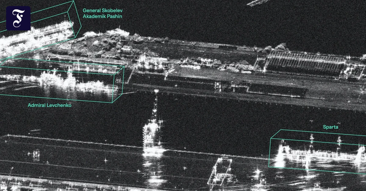
It is a huge radar installation that Russia is building near Gwardeisk in the Kaliningrad area. Previously unpublished satellite images of the Finnish company Iceye show three antenna rows of more than 500 meters in length. These converge in a star shape, the plant is double fenced. Together with other elements, the antennas form an over-the-horizon radar (OTH) that can detect aircraft and rockets at a distance of between 900 and 3000 kilometers. This includes Germany, France and the UK. The role of Kaliningrad is decisive for Russia militarily, because from there it can threaten the land connection between Poland and the Baltic states (Suwałki corridor). But also because missile and air defense is stationed there and the Baltic fleet has its base. In addition, according to Iceye, Kaliningrad’s importance for Russia as a hub in the field of sensors and electronic warfare, i.e. reconnaissance and interference of electronic signals, is growing. Iceye was originally supposed to study the environment In the Kaliningrad area there are therefore more than 20 locations. Other locations are added, such as the OTH radar currently under construction and a large circular antenna facility near Chernyachovsk. "Together, they provide Russia with a variety of opportunities to monitor activities across the region, from interception of satellite communications to detection of flight movements and ballistic missiles," according to a previously unpublished Iceyes report on security policy development in the Baltic Sea region, which is available to the F.A.Z. in excerpts. Iceye is based in Espoo, Finland, and operates microsatellites that use radar technology ("radar with synthetic aperture", SAR for short) to capture images and therefore work in bad weather and at night. Founded in 2014, the company is now one of Europe’s most important pillars in the attempt to become independent in space. Several NATO states and friendly countries use the satellites. They are also of great importance to the Ukrainian armed forces. Some countries operate the satellites themselves, have bought sovereign satellite systems, others only data packages. During a visit to the company headquarters in Espoo in May, the F.A.Z. was able to see the production of the satellites. These are astonishingly small devices weighing only about 100 kilograms, which are packed in boxes on site and then shipped to America, where they are shot into orbit by the company SpaceX. Iceye was founded by a Finn and a Poland. Originally, they wanted to observe the changes in the ice mass from a high altitude – hence the name of the company. For this purpose, as well as for the analysis of natural disasters, the satellite data, which can be retrieved in real time, is also in demand. But the demand from the military side is much greater. Due to the Russian war of aggression and doubts about the reliability of the USA, the company was catapulted into the center of European efforts to become militarily ready and independent. Tensions on the Baltic Sea have risen strongly Iceye is growing strongly, said the head of Germany, Philipp Herkelmann, in conversation with the F.A.Z. Satellite reconnaissance is in great demand, currently the company produces one satellite a week, next year the capacity will increase to two satellites per week. Overall, Iceye has hired more than 700 new employees this year, and growth is not slowing down. Last year, the company made a turnover of 250 million euros, for this year is expected to double. For 2027, the company targets a turnover of 1.2 billion euros. The company provides not only the technology, but also an interpretation of its recordings. The company is currently building analytical capacity for clarification; Satellite images are read out and combined with publicly available information to track events over longer periods of time and generate analyses. For the time being, the main focus will be on the Baltic States and the hinterland. Tensions in the Baltic Sea region have risen sharply in recent years. Drone overflights, cable damage, targeted disruptions to satellite navigation and cyberattacks are now commonplace. The Iceyes report on the region summarises this development. Parts of it are known. But the satellite images show that Russia is rebuilding its military capabilities around the Baltic Sea, while at the same time strengthening its reconnaissance and electronic warfare capabilities. When does a ship move differently than usual? They also show that Russia is also rearming militarily in the long term, building new barracks, storage and training facilities in Karelia and the Leningrad military district. For example, an equipment depot north of Petrozavodsk will be restored. Using automatic detection, Iceye also found that launchers were lifted in the Kaliningrad area at a mobile S-400 ground-to-air missile (SAM) site near Baltijsk. This indicates that they have been made operational. In addition, radar photos show that shelters for fighter aircraft were built on the naval aviator base of Chkalovsk – probably to protect them from drone attacks. A large ammunition complex is also being built near Pavlovka in the Slutsk district of Belarus. At the same time, the maritime activities of Russia are constantly monitored. In the port of Baltijsk, for example, it is possible to trace in detail when which ship arrives and departs. Using artificial intelligence (AI), warships are distinguished from merchant ships. Also in the prevention of attacks on the critical infrastructure..
Source: FAZ ›



Comments (0)
No comments yet.